Our Services
Commercial & Residential Solar Aerial Services
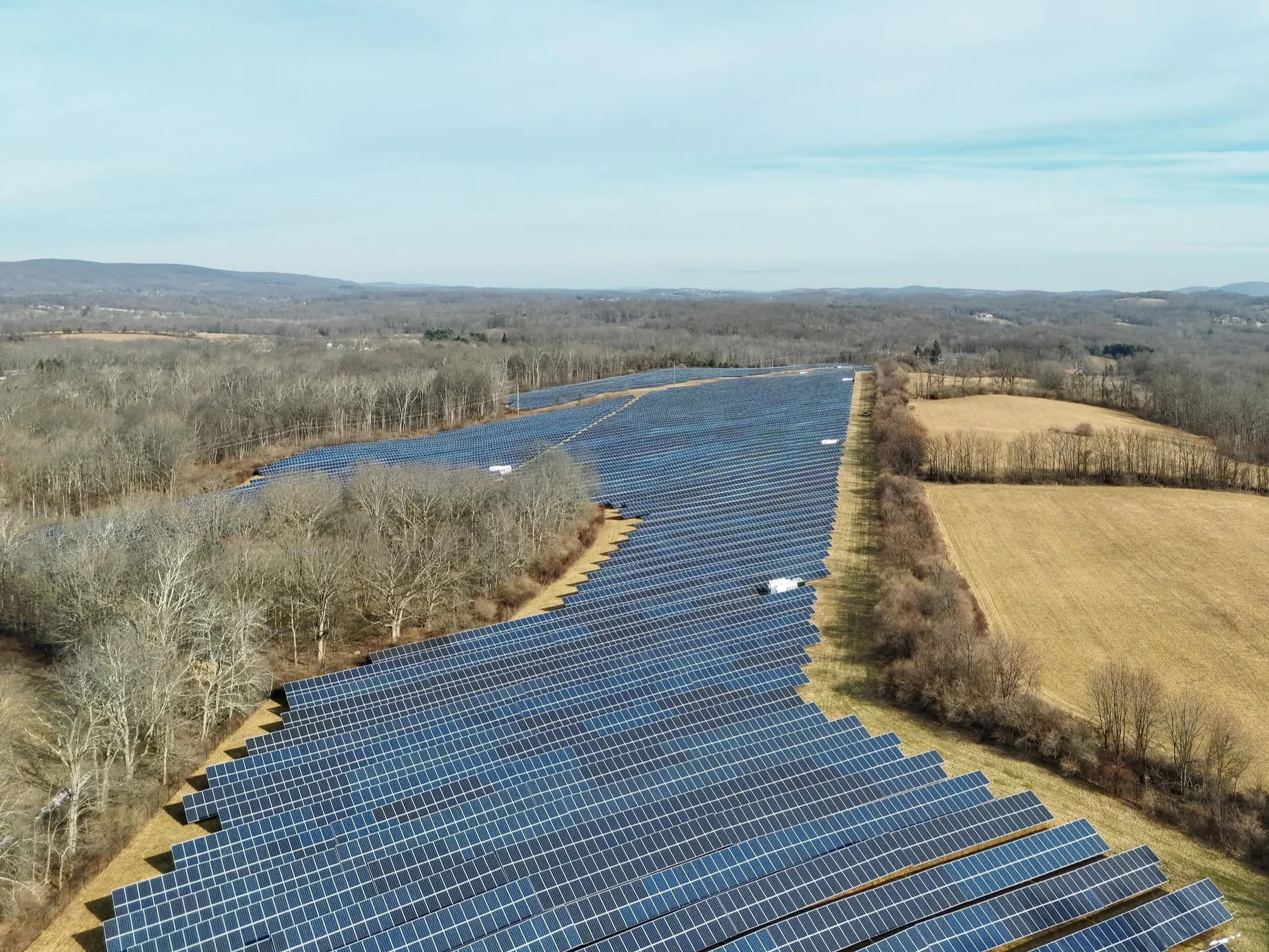
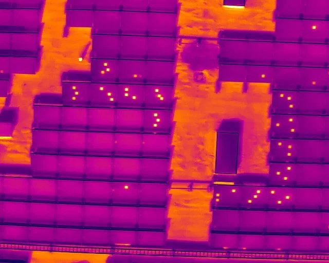
Professional aerial services supporting both commercial and residential solar installations. Our work includes high-resolution visual inspections, thermal assessments, site surveys, and project documentation designed to identify potential issues, verify installation quality, and support ongoing system performance. Using aviation-driven operating standards, we deliver accurate, reliable data suitable for new installations, existing systems, and large-scale solar farms. Our services help property owners, installers, and maintenance teams quickly identify underperforming panels, reduce downtime, and protect long-term solar investment performance.
We also work closely with our clients to ensure data collection aligns with your project timeline and reporting requirements. Our team schedules missions and delivers processed results quickly so the information you receive is timely, actionable, and ready when you need it for decision-making.
Real Estate and Special Event Aerial Services
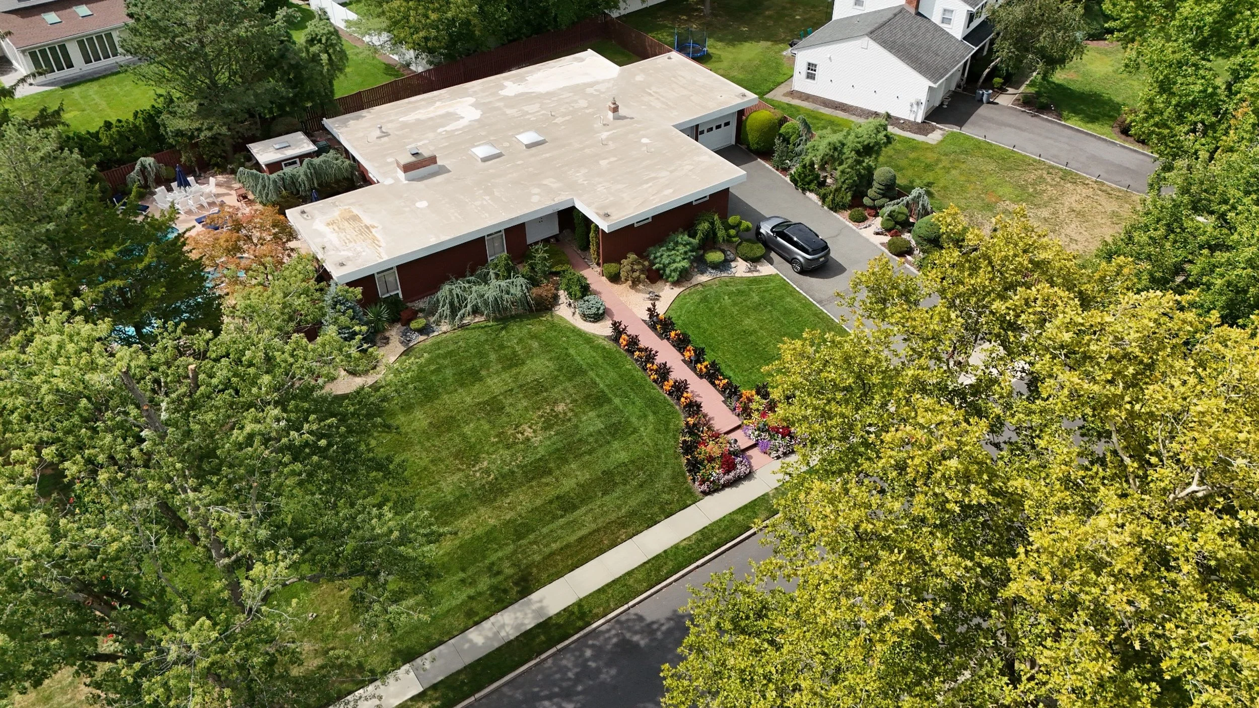
We provide professional aerial imaging services for real estate and special events, delivering high-quality visuals that enhance marketing, documentation, and presentation. For residential and commercial properties, our aerial imagery provides clear context, accurate perspectives, and detailed overviews that support sales, leasing, and property evaluation.
Our services help showcase property size, surrounding amenities, road access, nearby infrastructure, and neighborhood context—details that traditional ground photography often cannot capture. For commercial properties, aerial imagery can highlight parking areas, retail access points, nearby highways, and regional positioning, giving investors, brokers, and developers a better understanding of the property’s value and location advantages.
For residential listings, aerial photos and video provide a unique and engaging perspective that helps homes stand out in competitive markets. This allows potential buyers to better visualize the property layout, yard space, nearby features, and overall setting before even visiting the location.
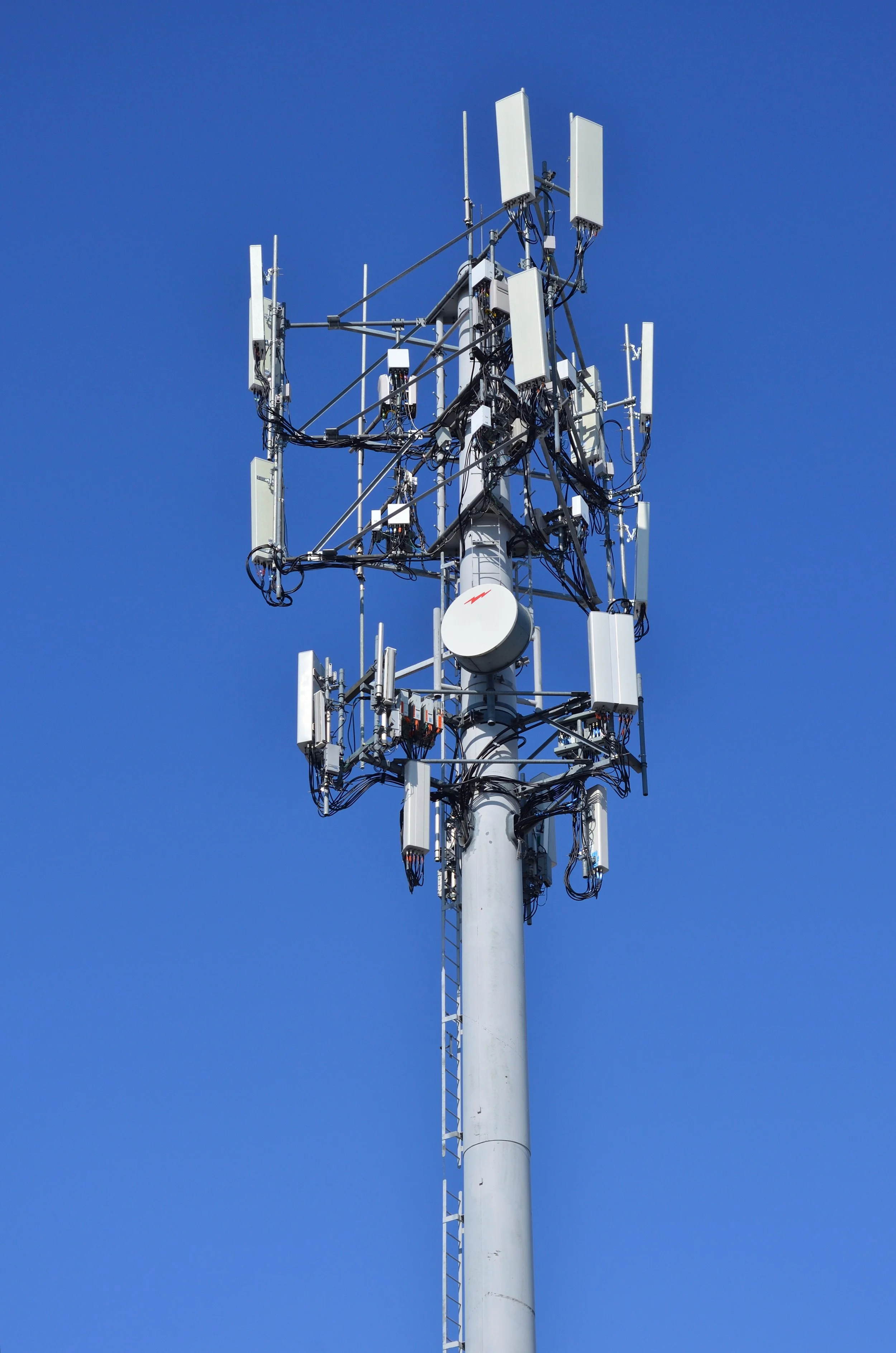
Aerial Inspection Services for Telecom and Critical Infrastructure
Professional aerial inspection services supporting telecommunications, utilities, and a wide range of industrial assets. Our inspections deliver high-resolution visual and thermal data to assess equipment condition, identify potential defects, and support maintenance planning without disrupting operations. From telecom towers and antennas to industrial facilities and infrastructure assets, our aviation-driven approach ensures inspections are conducted safely, efficiently, and in compliance with regulatory requirements.
Using advanced drone platforms and precision flight planning, we are able to capture detailed imagery of antennas, mounting hardware, cabling, structural components, and surrounding infrastructure that are often difficult or dangerous to access through traditional inspection methods. This allows asset owners and maintenance teams to quickly identify corrosion, loose components, alignment issues, and other developing problems before they lead to costly failures or service interruptions.
Our aerial inspections also help reduce the need for tower climbs, lifts, or temporary shutdowns, significantly lowering operational costs while improving worker safety.

Precision Roof & Facade Inspections
Drone-based inspections provide a safer, faster, and more precise alternative to traditional manual inspections. Without ladders or scaffolding, we capture high-resolution imagery of roofs, facades, parapets, drainage systems, and other critical building components while keeping workers safely on the ground.
Our technology allows us to identify damage, deterioration, and structural concerns quickly, often completing inspections in hours instead of weeks. With optional thermal imaging, we can also detect hidden issues such as moisture intrusion, insulation deficiencies, and heat loss.
The result is reduced risk, lower inspection costs, and detailed data that supports smarter maintenance, repairs, and property management decisions.
Compared to traditional inspections that require scaffolding, lifts, and large crews, drone inspections dramatically reduce operational costs while delivering faster results. In many cases, all we need is the property address to plan the mission, collect the data, and provide clear visual documentation for your review. This streamlined process allows clients to quickly receive actionable information without the delays, disruption, and expense of conventional inspection methods.
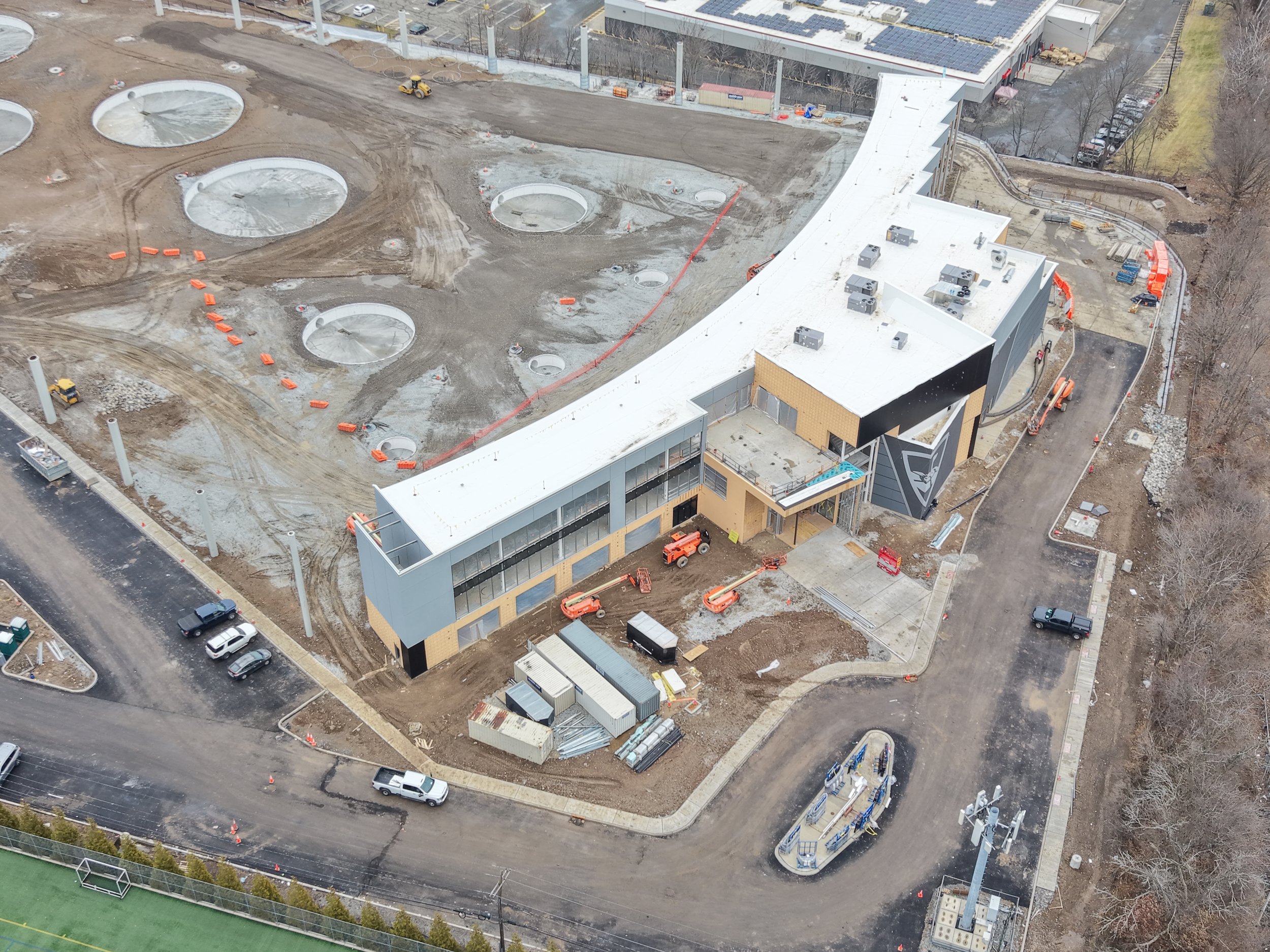
Construction Progress Monitoring
Our Construction Progress Monitoring service provides consistent aerial documentation throughout the life of a project, giving stakeholders clear visibility into progress, site conditions, and milestones.
What We Capture
Site-wide progress imagery
Key construction milestones
Phased development documentation
Visual records for stakeholders and reporting
Monitoring Method
Scheduled aerial site captures
Repeatable flight paths for consistency
Minimal site disruption
Deliverables
High-resolution progress images
Time-based comparisons
Optional visual presentations for meetings
Archived documentation for project records
Who This Service Is For
General contractors
Developers
Project managers
Lenders and investors
Key Benefits
Improved project visibility
Better communication with stakeholders
Objective documentation of progress
Reduced need for frequent site visits
Security, Event Monitoring, and Situational Awareness Services
We provide professional aerial security and monitoring services to support events, gatherings, and large-area operations. Our platforms are equipped with advanced thermal imaging and low-light (night vision) capabilities, enabling effective monitoring in daytime, nighttime, and low-visibility conditions. These services are designed to support licensed security contractors, event organizers, and law enforcement agencies with enhanced situational awareness and real-time data.
Our aircraft can operate discreetly to gather information without disruption, or visibly when a deterrent presence is desired. When requested and appropriate, our systems can be configured with a spotlight and speaker to support crowd direction, perimeter awareness, or verbal announcements under the coordination of on-site command or security leadership.
We are well suited for parking lot monitoring, perimeter observation, and wide-area coverage of large events where ground visibility is limited. Live aerial data can be shared with command centers and operations teams via secure wireless HDMI links, allowing multiple decision-makers to view incoming imagery in real time and respond effectively.
Contact Us
Whether you are planning a new project, need aerial inspection or documentation services, or are seeking a reliable aerial data partner, we are ready to assist. We work with commercial, industrial, and residential clients to understand project requirements and deliver professional aerial solutions tailored to specific operational needs. Contact us to discuss your project, request additional information, or connect with the appropriate member of our team.